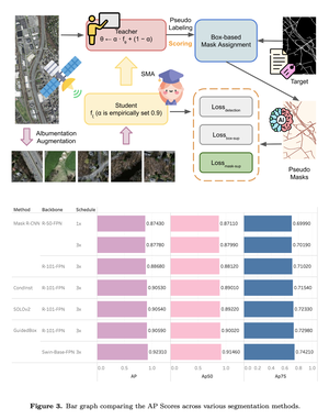
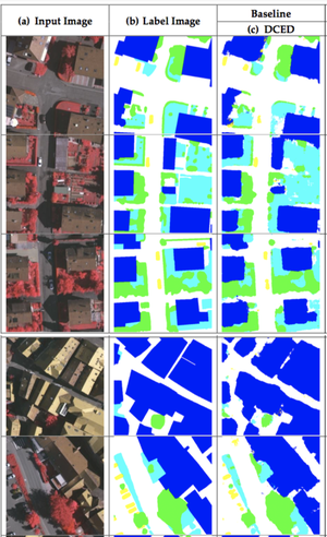
Remote Sensing

Semantic Segmentation on Remotely Sensed Images Using an Enhanced Global Convolutional Network with Channel Attention and Domain Specific Transfer Learning
In the remote sensing domain, it is crucial to complete semantic segmentation on the raster images, e.g., river, building, forest, etc., on raster images. A deep convolutional encoder–decoder (DCED) network is the state-of-the-art semantic segmentation method for remotely sensed images. However, the accuracy is still limited, since the network is not designed for remotely sensed images and the training data in this domain is deficient. In this paper, we aim to propose a novel CNN for semantic segmentation particularly for remote sensing corpora with three main contributions. First, we propose applying a recent CNN called a global convolutional network (GCN), since it can capture different resolutions by extracting multi-scale features from different stages of the network. Additionally, we further enhance the network by improving its backbone using larger numbers of layers, which is suitable for medium resolution remotely sensed images. Second, “channel attention” is presented in our network in order to select the most discriminative filters (features). Third, “domain-specific transfer learning” is introduced to alleviate the scarcity issue by utilizing other remotely sensed corpora with different resolutions as pre-trained data. The experiment was then conducted on two given datasets (i) medium resolution data collected from Landsat-8 satellite and (ii) very high resolution data called the ISPRS Vaihingen Challenge Dataset. The results show that our networks outperformed DCED in terms of 𝐹1 for 17.48% and 2.49% on medium and very high resolution corpora, respectively.
Semantic Segmentation On Medium-Resolution Satellite Images Using Deep Convolutional Networks With Remote Sensing Derived Indices
Semantic Segmentation is a fundamental task in computer vision and remote sensing imagery. Many applications, such as urban planning, change detection, and environmental monitoring, require the accurate segmentation; hence, most segmentation tasks are performed by humans. Currently, with the growth of Deep Convolutional Neural Network (DCNN), there are many works aiming to find the best network architecture fitting for this task. However, all of the studies are based on very-high resolution satellite images, and surprisingly; none of them are implemented on medium resolution satellite images. Moreover, no research has applied geoinformatics knowledge. Therefore, we purpose to compare the semantic segmentation models, which are FCN, SegNet, and GSN using medium resolution images from Landsat-8 satellite. In addition, we propose a modified SegNet model that can be used with remote sensing derived indices. The results show that the model that achieves the highest accuracy RGB bands of medium resolution aerial imagery is SegNet. The overall accuracy of the model increases when includes Near Infrared (NIR) and Short-Wave Infrared (SWIR) band. The results showed that our proposed method (our modified SegNet model, named RGB-IR-IDX-MSN method) outperforms all of the baselines in terms of mean F1 scores.