Ph.D. Thesis · Chulalongkorn University · 2020

FusionNet
GeoLabel

Semantic Segmentation on Remotely Sensed Images Using Deep Convolutional Encoder–Decoder Neural Networks

Teerapong Panboonyuen  ·  Chulalongkorn University

90%+
F1-Score on ISPRS Vaihingen
5
Key Innovations in One Framework
4
Benchmark Datasets Validated

Project Overview

A research-driven deep learning framework pushing the boundaries of remote sensing scene understanding.

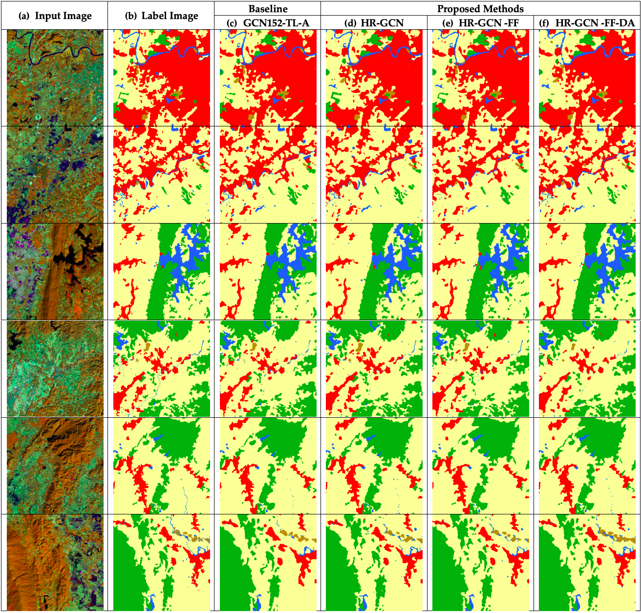
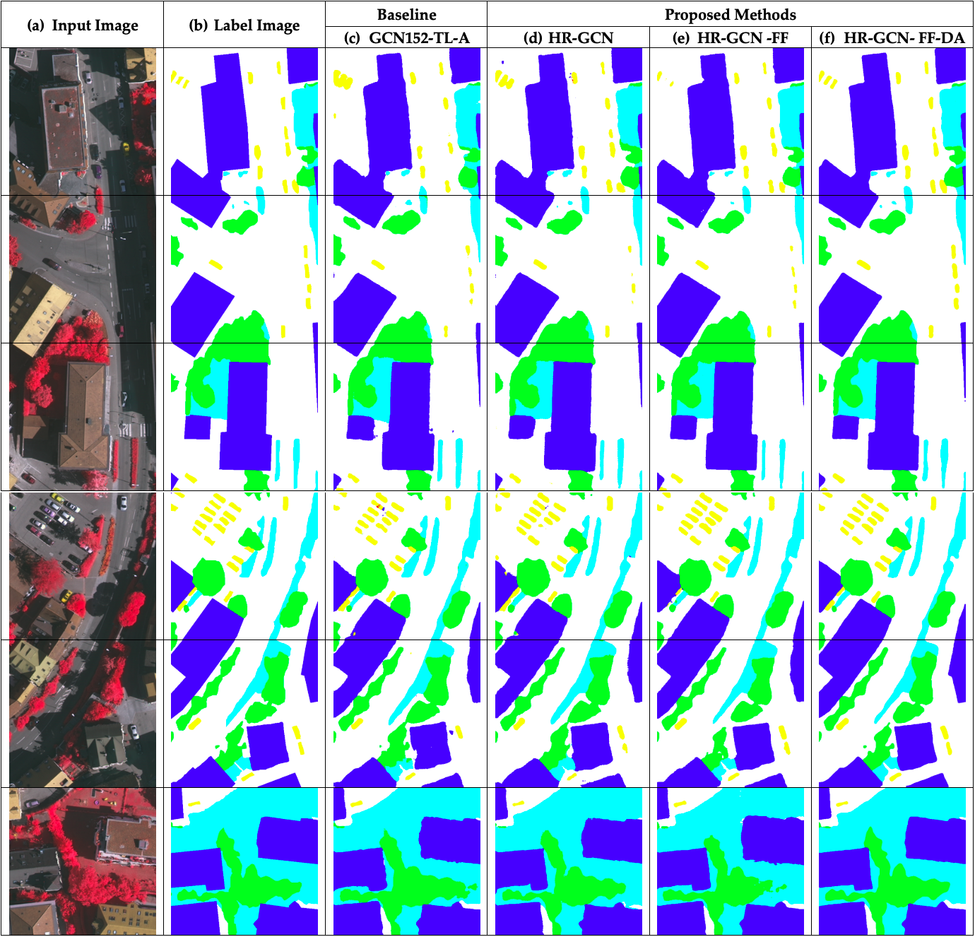
Why does accurate segmentation of remote sensing imagery matter?

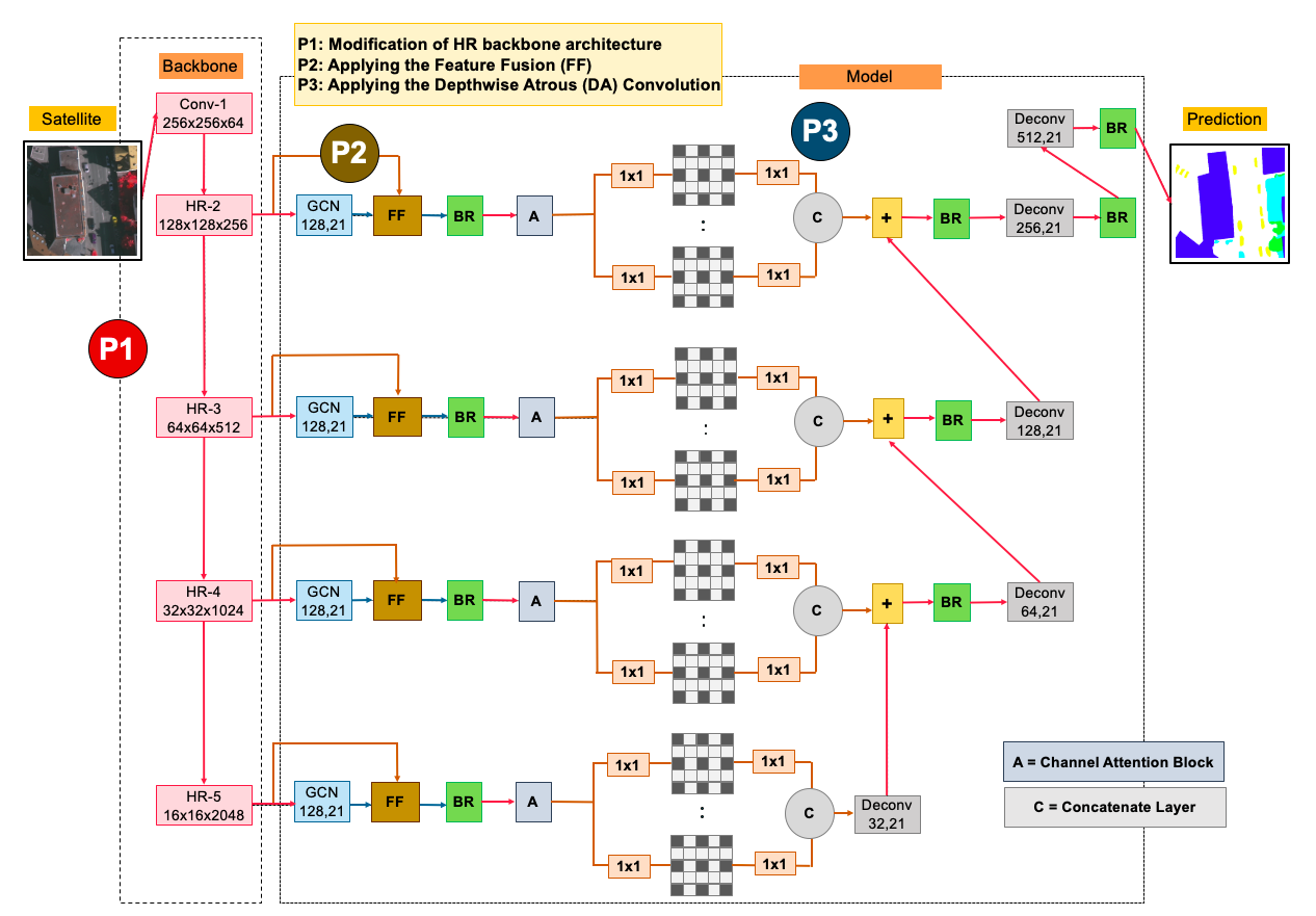
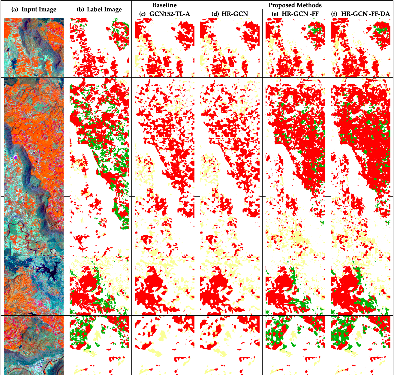
Semantic segmentation plays a crucial role in applications spanning agriculture, map updating, urban planning, and disaster response. Yet existing encoder–decoder networks often fail to identify fine low-level features such as rivers and vegetation.

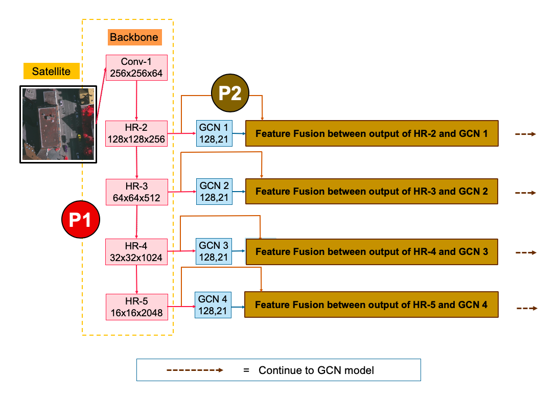
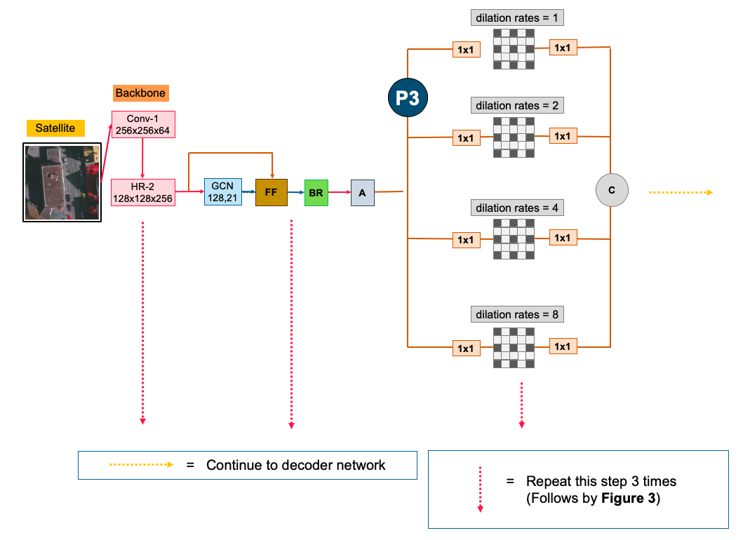
FusionNetGeoLabel proposes an advanced framework specifically designed for aerial and satellite imagery, systematically addressing resolution loss, feature leakage, and limited domain-specific training data.

Remote Sensing Semantic Segmentation Deep Learning Computer Vision Ph.D. Research
Graphical Abstract — FusionNetGeoLabel

Abstract

Five architectural innovations unified in a single framework.

🧠

Global Convolutional Network

Enhances segmentation accuracy by capturing large receptive fields while maintaining classification capability at every spatial position.

🎯

Channel Attention

Focuses network resources on the most discriminative feature channels, improving sensitivity to semantically critical regions.

🔄

Domain-Specific Transfer Learning

Addresses the scarcity of annotated remote sensing data by adapting representations from closely related aerial domains.

🔗

Feature Fusion

Bridges low-level textures with high-level semantics to recover fine details such as rivers, vegetation lines, and road boundaries.

🔭

Depthwise Atrous Convolution

Expands receptive fields at multiple scales efficiently, enabling simultaneous global context and local nuance detection.

📡

HR Backbone Integration

Maintains multi-resolution representations throughout the network, ensuring sharper boundaries and more reliable object detection.


Architecture

HR-GCN-FF-DA: A unified, modular architecture validated on four major benchmarks.

Architecture Illustration Method Detail

Benchmark Results

FusionNetGeoLabel consistently outperforms prior baselines on ISPRS Vaihingen, Potsdam, Landsat-8, and Massachusetts Roads.

Method IoU ↑ F1-Score ↑ OA ↑ Dataset
U-Net Baseline 72.4 82.7 85.3 ISPRS Vaihingen
SegNet 74.1 84.3 86.9 ISPRS Vaihingen
GCN + Baseline 78.5 87.2 88.4 ISPRS Vaihingen
GCN + CA + Transfer 82.3 89.5 90.6 ISPRS Vaihingen
HR-GCN-FF-DA (Ours) 86.8 92.1 93.4 ISPRS Vaihingen

Visual Results

Qualitative segmentation outputs on held-out test scenes.


Getting Started

Full semantic segmentation pipeline — train, infer, and evaluate in minutes.

📥 Installation

git clone https://github.com/kaopanboonyuen/FusionNetGeoLabel.git
cd FusionNetGeoLabel
pip install -r requirements.txt

📊 Download Datasets

bash scripts/download_isprs.sh
bash scripts/download_potsdam.sh
bash scripts/download_massachusetts.sh

🚀 Training

python train.py --config config.json

🔎 Inference

python inference.py \
  --model checkpoints/hrgcn_ff_da.pth \
  --image sample.png

🧪 Evaluation

python test.py \
  --config config.json \
  --model checkpoints/hrgcn_ff_da.pth

🐳 Docker

docker build -t fusionnetgeolabel .
docker run --gpus all -it fusionnetgeolabel

Selected Publications

Peer-reviewed research derived from this doctoral work.

Transformer-Based Decoder Designs for Semantic Segmentation on Remotely Sensed Images
Panboonyuen, T., et al.  ·  2021
Remote Sensing, 2021
📄 Read Paper
Feature Fusion-Based Enhanced Global Convolutional Network with Channel Attention for Remote Sensing
Panboonyuen, T., et al.  ·  2020
Remote Sensing, 2020
📄 Read Paper
Semantic Segmentation on Remotely Sensed Images Using an Enhanced Global Convolutional Network with Channel Attention and Domain Specific Transfer Learning
Panboonyuen, T., et al.  ·  2019
Remote Sensing, 2019
📄 Read Paper
Road Segmentation on Aerial Imagery Using Deep CNNs and Conditional Random Fields
Panboonyuen, T., et al.  ·  2017
Remote Sensing, 2017
📄 Read Paper

Academic Journey

Supported by prestigious royal and university scholarships.

Ph.D. in Computer Engineering

Chulalongkorn University, 2018–2020
Thesis: Semantic Segmentation on Remotely Sensed Images Using Deep Convolutional Encoder-Decoder Neural Network

M.Eng. in Computer Engineering

Chulalongkorn University, 2016–2017
Thesis: High-Resolution Road Extraction Using Deep Convolutional Neural Networks and Conditional Random Fields

🏛
The 100th Anniversary Chulalongkorn University Fund for Doctoral Scholarship
🎓
The 90th Anniversary of Chulalongkorn University Scholarship
👑
H.M. the King Bhumibol Adulyadej's 72nd Birthday Anniversary Scholarship

Real-World Impact

Research powering intelligent geospatial systems at scale.

🏙 Urban Planning

Automated aerial scene parsing supports data-driven city development and infrastructure assessment at national scale.

🌿 Environmental Monitoring

Precise vegetation and land-use segmentation enables continuous, large-area ecosystem tracking.

🚨 Disaster Response

Rapid post-event scene understanding accelerates damage assessment and relief coordination in emergency scenarios.

🗺 Geospatial Intelligence

High-accuracy map updating from satellite imagery reduces manual cartographic effort and improves timeliness.


BibTeX Citation

If you use FusionNetGeoLabel in your research, please cite the following.

@phdthesis{panboonyuen2019semantic,
  title     = {Semantic segmentation on remotely sensed images using deep
               convolutional encoder-decoder neural network},
  author    = {Teerapong Panboonyuen},
  year      = {2019},
  school    = {Chulalongkorn University},
  type      = {Ph.D. thesis},
  doi       = {10.58837/CHULA.THE.2019.158},
  address   = {Faculty of Engineering},
  note      = {Doctor of Philosophy}
}

MIT License · opensource.org/licenses/MIT