Custom Heuristic Uncertainty-Guided Loss
for Accurate Land Title Deed Segmentation
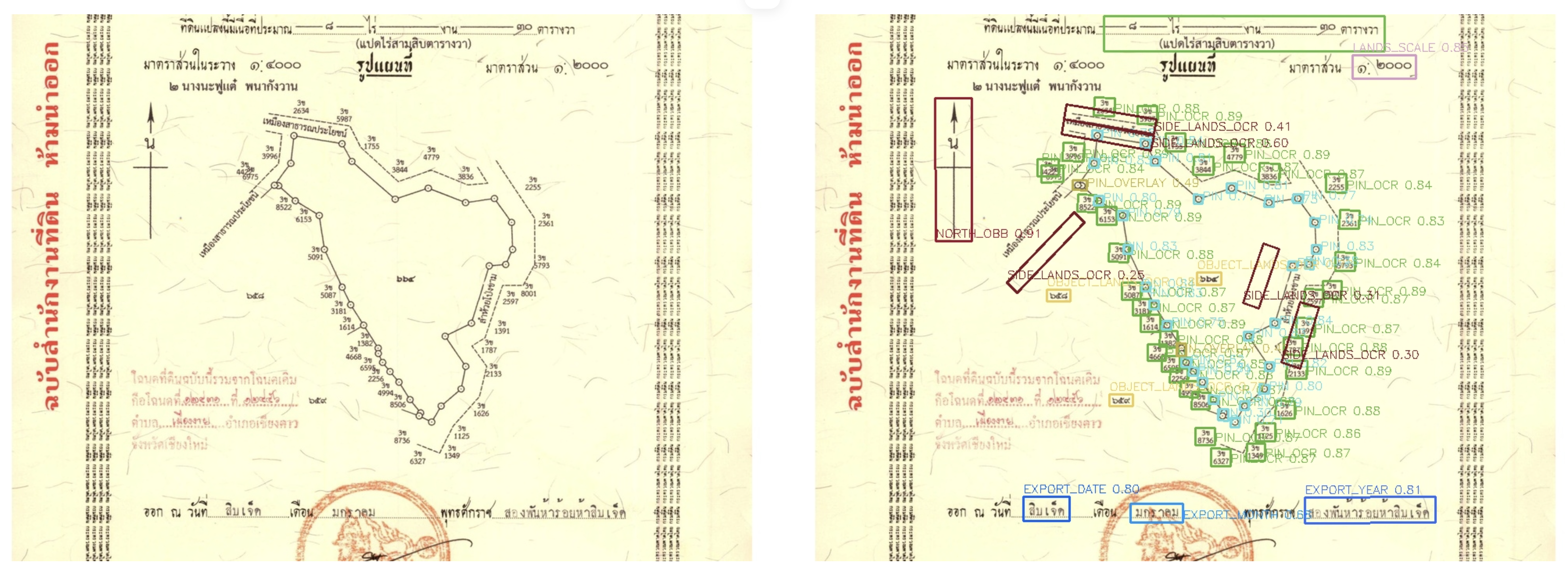
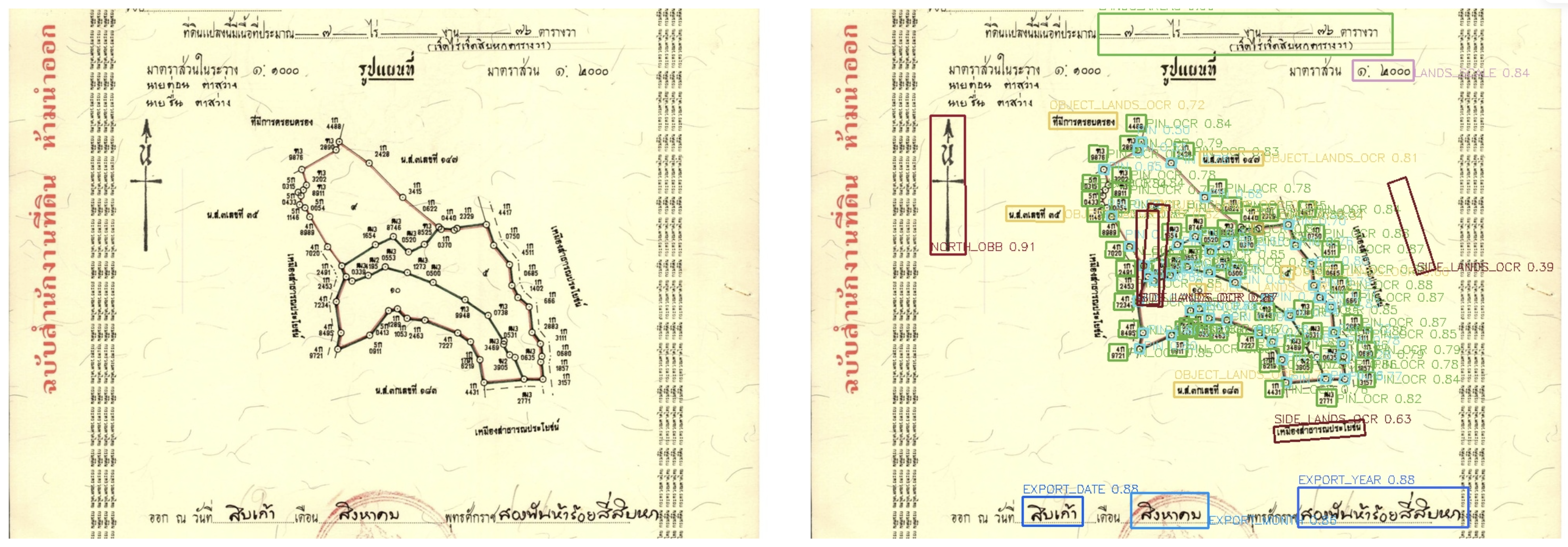
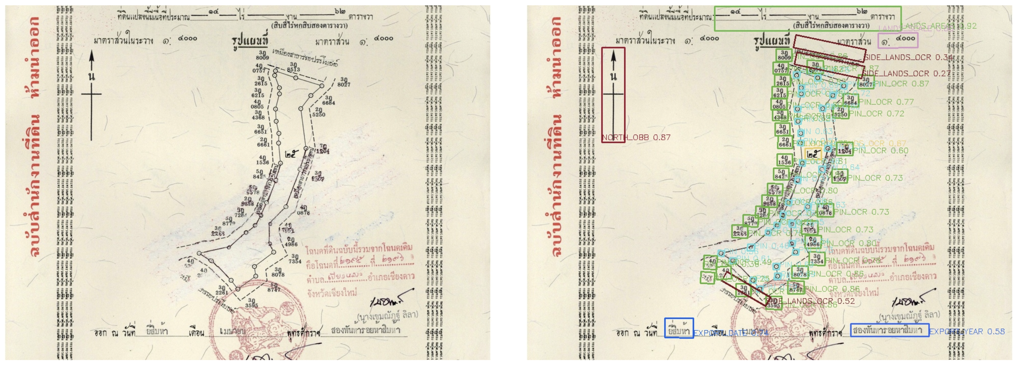
Segmentation of legal cadastral documents remains extremely challenging under severe real-world degradation.
Existing systems fail under handwriting overlays, faded scans, official stamps, blur, and layout corruption.
Even minor recognition errors can produce critical legal inconsistencies in national-scale document digitization pipelines.
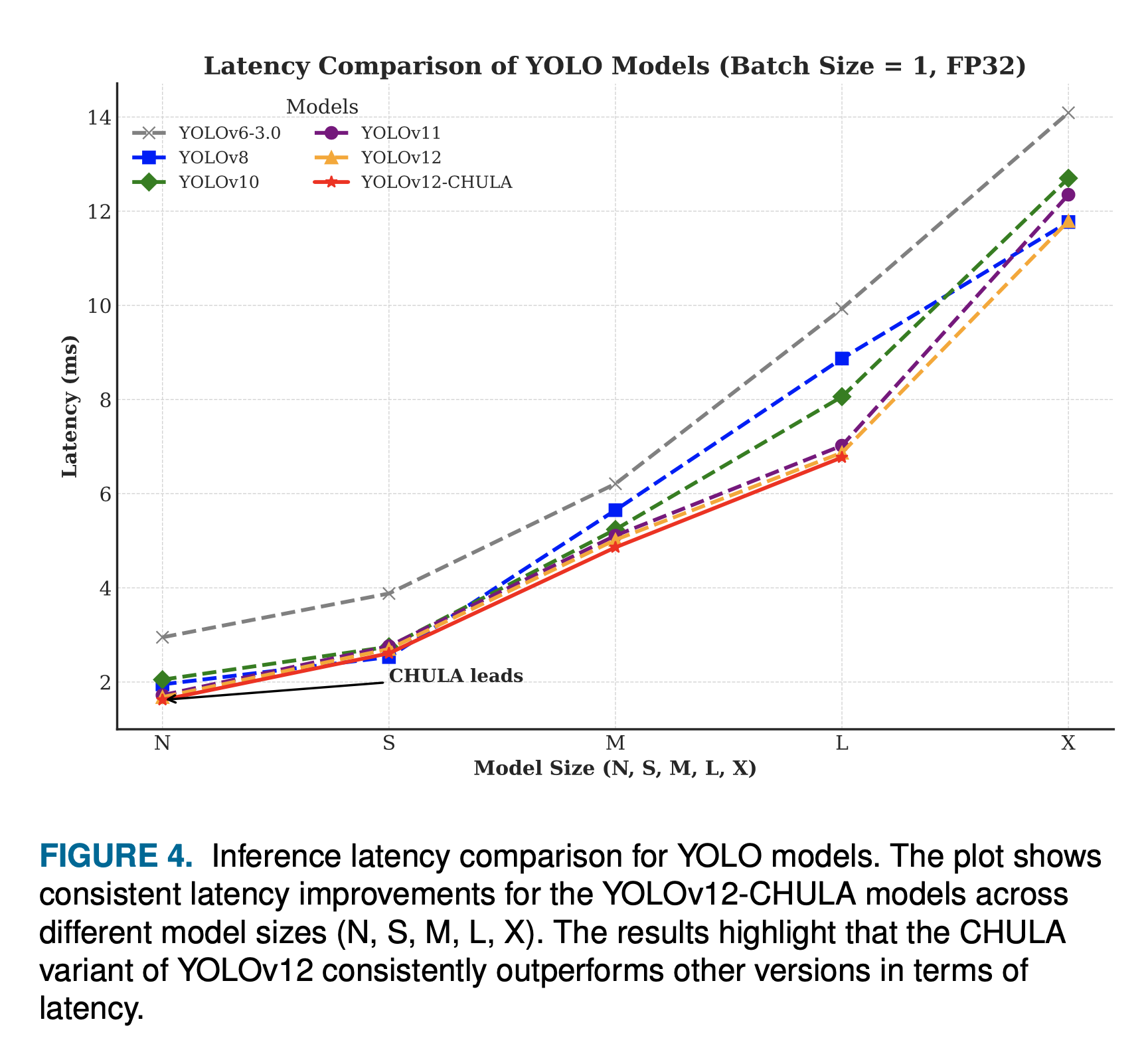
CHULA introduces a custom heuristic uncertainty-guided loss for robust land title deed segmentation under real operational constraints.
Robust segmentation through heuristic uncertainty-guided loss formulation.
Detect unreliable visual regions under severe degradation, handwriting contamination, and scanning artifacts to guide adaptive loss weighting.
Custom loss function that dynamically suppresses noisy regions including blur, occlusion, official stamps, and structural corruption during training.
Preserve cadastral boundary consistency for reliable downstream legal verification and national-scale document processing.
CHULA consistently outperforms existing baselines across challenging cadastral document benchmarks.
| Method | OCR Accuracy β | NED β | Cadastral Match β |
|---|---|---|---|
| CRNN | 61.3 | 5.42 | 48.1 |
| TrOCR | 71.4 | 4.82 | 57.2 |
| PARSeq | 74.1 | 3.94 | 63.5 |
| CHULA (Ours) β SOTA | 92.6 | 1.64 | 91.7 |
Real-world segmentation inference under severe cadastral degradation.
Designed for national-scale public infrastructure deployment.
Enable scalable cadastral digitization for government administrative systems across Thailand and beyond.
Improve reliability and consistency in official legal document processing pipelines.
Reduce manual workload in large-scale document archival and processing pipelines.
Support AI-driven digital transformation for governmental services at national scale.
Real Thai land title deeds β processed at national scale.
Every bounding box is a field extracted by CHULA under extreme real-world degradation.
SAMPLE_01
β High Confidence Fields
A degraded Chiang Rai land deed with overlapping handwritten marks and an official circular stamp. CHULA successfully localizes PIN fields, side-land measurements, north arrow, export date and year β all under severe visual noise. Note the high confidence scores even on occluded fields.
SAMPLE_02
24+ Fields Detected
A Chiang Rai parcel with an irregular polygon boundary and dense text distribution around the perimeter. CHULA detects PIN nodes along each boundary segment, land-scale metadata, and neighbor parcel labels (SIDE_LANDS_OCR) with robust localization despite layout complexity.
SAMPLE_03
40+ Fields Detected
The most challenging case: a dense urban parcel map with dozens of PIN coordinate fields, multiple SIDE_LANDS neighbor annotations, and a partially visible north arrow. CHULA achieves high-confidence detections across 40+ fields simultaneously, demonstrating scalability to the most complex cadastral documents in the national archive.
This research was supported by a prestigious postdoctoral fellowship enabling frontier AI for national infrastructure.
This work was supported by the C2F (The Second Century Fund) PostDoctoral Fellowship Program at Chulalongkorn University. C2F accelerates frontier AI research bridging academic excellence with national-scale real-world deployment β enabling CHULA to move from laboratory research to public digital infrastructure serving all of Thailand.
CHULA demonstrates that robust segmentation for legally sensitive documents requires more than stronger recognition models β it requires uncertainty-aware loss formulation grounded in operational constraints and real-world document characteristics.
Cite our work if you find it useful for your research.
@article{panboonyuen2025chula, title = {CHULA: Custom Heuristic Uncertainty-Guided Loss for Accurate Land Title Deed Segmentation}, author = {Panboonyuen, Teerapong}, journal = {IEEE Access}, year = {2025}, publisher = {IEEE} }